Click on a photo to see a larger version of the image.
Showing posts with label geology. Show all posts

Saturday, September 02, 2017

Mount St. Helens

After seeing the August 21, 2017 Total Solar Eclipse, we headed for Mount St. Helens, the volcano in southwestern Washington that produced the largest volcanic eruption of the 20th century and the largest landslide recorded in history on May 18, 1980.  The eruption killed 57 victims as the north side of the mountain collapsed and blew out.  The landslide devistated a huge area mostly north of the volcano and an ash cloud rose to more than 7 miles, covering a huge area to the northeast of the mountain as the volcano lost 1313 feet from it's height.  The appearance of the formerly symmetric volcano was changed in minutes to a large horseshoe shape and over the next 6 years, a volcanic dome grew inside the crater atop the volcano.  Activity is greatly reduced but continues off and on, adding to the volcanic dome complex near the summit.

This photo shows Mount St. Helens from the north as viewed from the Johnston Ridge Observatory.  This location used to be called Coldwater ridge but was renamed after the May 18, 1980 eruption after the USGS geologist David Johnston who was killed during the eruption while manning some measuring equipment near this location.  His body was never found so he is almost certainly still very nearby.  It was a bit of an eerie feeling standing near Johnston's final resting place.  Johnston was one of the faces of Mount St. Helens during the nearly 2 months of volcanic activity around the mountain prior to the catastrophic eruption of May 18.

Spirit Lake was inundated by the landslide debris, sloshing water 800 feet up the slope of the hills to its north and burying the many cabins around the lake including the octogenerian Harry Truman who refused to leave the area despite the warnings of impending eruption under as much as 600 feet of debris.

This closeup of the summit of Mount St. Helens is the first of 3 images showing the horseshoe shaped summit left over from the eruption.  The clouds surround the summit area, especially the lava dome which grew after the eruption.

This second image shows the lava dome a little better. You can see a vertical column of steam rising from the vent.

Here is a closer view of the lava dome and the steam vent on its summit.

As we drove out of the park, we watched a pretty sunset over the mountain.

The magic hour around sunset produces some spectacular lighting and this day was no exception to that.

Thursday, July 31, 2014

Lava River Cave

After visiting Lava Butte at Lava Lands south of Bend Oregon, we headed for nearby Lava River Caves.  These caves resulted from lava flows in the Newberry Volcano complex which includes cinder cones like Lava Butte.  The youngest lava flows in the area date to about 7000 years ago (not long after Crater Lake formed from Mount Mazama about 7700 years ago).  This lava cave is about a mile long and it is well visited, including a ranger guided tour of most of its length.

The entrance to the cave sits in a depression that is maybe 200 meters long with entrances at both ends and the area in the middle is a collapsed section of the cave that is overgrown with plants taking advantage of the relatively damp and cool environment compared to the surrounding landscape.  This image was taken with my 18-250mm Sigma lens at 18mm focal length with an exposure of 1/40 seconds at f/5.6, ISO 400.

Looking down into the cave entrance, it is surprisingly large with lots of collapsed rocks around the entrance but a reasonable path for visitors.  This image was taken at 18mm focal length with an exposure of 1/64 seconds at f/4.5, ISO 1600.

The view back to the entrance from about 100 feet into the cave.  This image was taken at 18mm focal length with an exposure of 1/40 seconds at f/3.5, ISO 6400.

Another view back towards the entrance from farther inside the cave.  My Canon 70D did a great job with a high ISO setting in the relatively dark cave.  This image was taken with my 10mm fisheye lens with an exposure of 1/10 seconds at f/2.8, ISO 6400.

The ranger guiding us through the cave stops to talking about the large ceiling lava tube with high water marks on walls etched by lava flowing through the cave.  You can also see the change in character of the marks from top down to the floor.  This image was taken with my 10mm fisheye lens with an exposure of 1/10 seconds at f/2.8, ISO 3200.

 Our guide uses his headlamp to show off the huge size of the cave here with about a 40 foot tall ceiling.  This image was taken with my 10mm lens and an exposure of 1/4 seconds at f/2.8, ISO 3200.

About 0.8 miles into the cave is one of the least disturbed sections of floor, though it was damaged by early visitors, it is not as badly damaged.  This section is called "Sand Gardens".  It is mostly sediment from deposits that entered the cave long after the lava flowed.  This image was taken with my 10mm fisheye and an exposure of 1/16 seconds at f/2.8, ISO 6400.

Sunday, September 02, 2012

Flaming Gorge geology

As we approached the south end of Flaming Gorge National Recreation Area, we found ourselves in an area with stratified cliffs showing the geology of the area in spectacular views.  This image was taken with my 75-300mm lens at 75mm focal length with an exposure of 1/800 seconds at f/5.6, ISO 200.

The top of this cliff has an interesting layer a few feet thick that differs from adjacent layers. This image was taken at 75mm focal length with an exposure of 1/1000 seconds at f/5.6, ISO 200.

 A closeup of a few layers in a cliff wall.  This image was taken at 75mm focal length with an exposure of 1/400 seconds at f/5.6, ISO 200.


Finally a view of the lake that fills the Flaming Gorge Recreation Area from the roadway at one of the scenic viewpoints.  We could see boats and water skiers.  This image was taken with my 24mm lens and an exposure of 1/125 seconds at f/11, ISO 100.
This last image shows a number of boats on the lake including one with a skier in tow.  This image was taken at 300mm focal length with an exposure of 1/200 seconds at f/11, ISO 100.

Tuesday, August 28, 2012

Confluence of the Yellowstone River and Tower Creek

Fun with special affects, this exposure was long enough to smear the rivers flow significantly with an exposure of 1 second at f/22, ISO 100 using my 24mm lens.  The river bends to the left, flowing away from me here and into the canyon wall.

Upstream from the confluence, the Yellowstone River turns a bend below this shallow canyon wall in the distance.  This image was taken with my 24mm lens and an exposure of 1/25 seconds at f/4, ISO 100.

Tower Falls is far left of this image but the creek below the falls flows down and intersects the Yellowstone River at the lower left corner of this image. This image was taken with my 24mm lens with an exposure of 1/30 seconds at f/3.2, ISO 100.

To show the whole bend in the Yellowstone River, I used my 10mm fisheye lens for this shot.  The Tower Creek enters the Yellowstone River on the lower left corner of this frame, just below the small rapids in the rover below the yellow cliff face.  The river flows from the right, towards the left in this image.  The area smelled of sulfur which may have come from what may have been a small fumerole at the base of the cliff slightly upstream in the Tower Creek canyon.  I also suspect the yellow highlights in the cliff or canyon wall may be the result of sulfur rich deposits.  This image was taken with an exposure of 1 second at f/22, ISO 100.

Saturday, August 25, 2012

Mammoth Hot Springs


The Mammoth Hot Springs are on the north end of the Yellowstone National Park.  The area housed a Military expedition that was used to "tame" the area in the early days.  The hot springs are composed of a number of terraces with bubbling hot springs that drain downhill, forming the terrace features as the minerals in the water settle out into the landscape.  The grey-white limestone deposits are called travertine.  The material looks a lot like snow or ice from a distance.  You can also see a storm which moved into the area while we were there and chased us back into the car.  This image was taken with my 24mm lens and an exposure of 1/320 seconds at f/5.6, ISO 100.

The trails for visitors are on man made boardwalks to allow visitors to get close to the hot springs without damaging them.  Looking down into one of the terraces below the boardwalk shows the pools of water in the terraces and shows some of the structure found in the terraces.  This image was taken at 75mm focal length with an exposure of 1/250 seconds at f/5.6, ISO 100.

These fresh terrace structures show the wide variety of colors and structures.  Some of the features almost look like snow and ice structures.  This image was taken with my 24mm lens and an exposure of 1/400 seconds at f/5.6, ISO 100.

 A closeup of the terrace from the previous image showing some of the complex structures and perhaps you can see the slow trickle of water flowing downhill.  This image was taken at 75mm focal length with an exposure of 1/320 seconds at f/5.6, ISO 100.

 The travertine covered landscapes have a variety of textures and colors to be seen.  This image was taken at 75mm focal length with an exposure of 1/200 seconds at f/5.6, ISO 100.

This is a lower pool at the top of one of the lower terraces.  The pools can be seen steaming and it produces very colorful deposits.  This image was taken with my 75-300mm lens at 75mm focal length with an exposure of 1/320 seconds at f/5.6, ISO 400.

Monday, August 20, 2012

Campground views

After our late afternoon visit to Old Faithful in Yellowstone National Park on Thursday July 26, we drove east past Yellowstone Lake and out the East Entrance towards Cody Wyoming - a place I'd visited during one of my families trips between Oregon and Michigan when I was 8 years old.  We found a campground with a couple empty camp sites well after dark at the Newton Creek Campground along the North Fork of the Shoshone River.  We were greeted by these views in the morning when we finally saw our surroundings in sunlight.  The steep hills and cliffs in the area are composed of sandstone debris flows with many sharp features including at least one window and one cave (see below) visible from this campground.  The image above is a panorama composed of 4 portrait format images taken with my 24mm lens with exposures of 1/1250 seconds at f/4, ISO 400.

Just off the left edge of the panorama above was this small cave feature near the top center.  This first image shows the setting for the next two and was taken with my 24mm lens with an exposure of 1/125 seconds at f/5.6, ISO 100.

Zooming in some, you can see more detail along with hints of many of the features on the cliffside in which this cave sits.  This image was taken with my 75-300mm zoom at 75mm focal length with an exposure of 1/125 seconds at f/5.6, ISO 100.

Finally, zoomed in to 300mm focal length, you can see the cave interior as well as the sharp hoodoos on the left as well as along the top of the cliff and some coarse layering in the sandstone cliffs below the cave.  This image was taken with an exposure of 1/320 seconds at f/5.6, ISO 400.

Friday, August 17, 2012

Clepsydra Geyser

This is Clepsydra Geyser which was active continuously while we were in the area.  We saw it first from the road as we approached the parking area and is known for its almost continuous eruptions these days.  This image was taken with my 24mm lens with an exposure of 1/320 seconds at f/8, ISO 100.

Thursday, August 16, 2012

Fountain Paint Pot and nearby thermal features.

This is the Fountain Paint Pot which gave this trail its name.  These "Mudpots" are fairly thick in the late summer but the mud in the middle of this is continuously bubbling and boiling.  It does appear to have the thickness of paint.  This image was cropped from a frame taken with my 10mm fisheye with an exposure of 1/640 sec, f/8, ISO 100.

This is the very noisy Fumaroles.  This hissing fumerole was being outdone this day by its neighbor below, the Red Spouter.  It smelled of sulfur here too. This image was taken with my 10mm fisheye with an exposure of 1/500 sec at f/8, ISO 100.

Red Spouter originated in 1959 with the Hebgen Lake Earthquake.  It was mostly just steaming when we were there, but it apparently changes its typical features during the year from a muddy hot spring in the spring  & early summer to small geyser that splashes reddish water several feet in the air to a big mudpot and then a hissing fumerole.  They sounded like the hissing fumerole the day were were there

Leather Pool has undergone changes in the recent past.  It supported leather-like thermophilic bacteria before the Hebgen Lake Earthquake in 1959 but became boiling after the earthquake, killing off the micro organisms and has since cooled back down.  This image was taken with my 10mm fisheye with an exposure of 1/200 seconds at f/8, ISO 100.

Wednesday, August 15, 2012

Silex Spring & Bacterial Mats

This is an image of pretty blue Silex Spring along the short Fountain Paint Pot Trail along the road about midway between Madison and Old Faithful.  This image was taken with my 10mm fisheye lens with an exposure of 1/400 seconds at f/8, ISO 100.

Along the boardwalk from the parking lot you can see the Bacterial Mats below the steaming (even in summer, so you can imagine how hot the water is!) Silex Spring.  This image was taken with my 75-300mm zoom at 75mm focal length.  The exposure of 1/500 seconds at f/8, ISO 100.

Someone dropped their hat into the Bacterial Mats - I would have left my favorite hat there too....  This image was taken at 300mm focal length with an exposure of 1/500 seconds at f/8, ISO 100.

Monday, August 13, 2012

The Three Buttes

On our way from Craters of the Moon National Monument to Yellowstone National Park, we stopped along the road to look at the Three Buttes.  From left to right is East Butte, Middle Butte and Big Butte.  Big Butte can be seen from Craters of the Moon for example in this image taken from near the Campground that I published on this blog recently.  This is a panorama assembled from seven images taken with my 24mm lens on my 20D.

Sunday, August 12, 2012

The lone tree on top of Inferno Cone - take II

You can see the lone tree on top of Inferno Cone in this view from the loop road heading back to the entrance area of Craters of the Moon National Monument.  You can also see the shoulder on the right flank of Inferno Cone that fools climbers into thinking they've got a short hike to the summit ahead of them. This image was taken with my 24mm lens and an exposure of 1/160 seconds at f/8, ISO 100.

Saturday, August 11, 2012

The Great Rift

This panorama was assembled from 9 images taken with my 24mm lens on my 20D during our visit to Craters of the Moon National Monument at the end of our Ranger led Broken Top Hike more than 2 weeks ago.  It shows a section of the "Great Rift", a  fracture that is the cause of the Craters of the Moon lava flows.  You can trace the sources of the lava flows to sources right along the Great Rift, from its north end to its south end.

The leftmost image from the pan shows the flank of Broken Top cinder cone on the right as well as distant cones in the background that run along the Great Rift to the north.  This image was taken with my 24mm lens on my 20D and an exposure of 1/160 seconds at f/8, ISO 100.

The rightmost image in the pan shows the flank of Broken Top cinder cone on the left as well as the flank of Big Cinder Butte on the right with the Great Rift running generally southward towards the cinder cone.  This image was taken with my 24mm lens looking into the sun with an exposure of 1/100 seconds at f/8, ISO 100.

Friday, August 10, 2012

Hiking among the lava flows

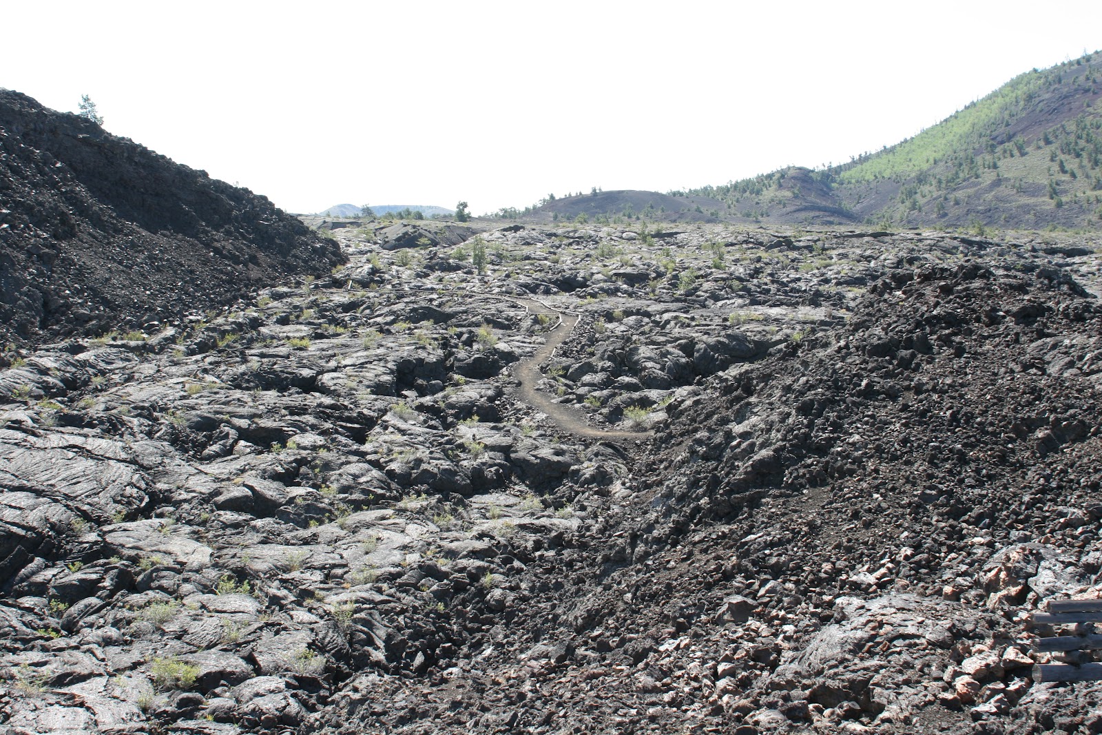
Our group, led by Craters of the Moon park ranger Rebecca, hikes along the trail at the base of Broken Top cinder cone with Pahoehoe lava flows to their left. This image was taken with my 24mm lens and an exposure of 1/200 seconds at f/8, ISO 100.

This panorama shows the lava flows between Broken Top cinder cone (behind the photographer) and Big Cinder Butte at the left in this pan.  This image was built from 7 frames taken with my 24mm lens on my 20D.

This is a Pahoehoe flow along the trail.  You can see a bluish tint to some of the surface layer.  The image was obtained with my 24mm lens with an exposure of 1/200 seconds at f/8, ISO 100.

The section of this Pahoehoe lava was pushed up after it cooled so that you can see the layering inside.  This image was taken with my 24mm lens and an exposure of 1/160 seconds at f/8, ISO 100.